Consider the following statements: ...Read more
Poll Results
Please login to vote and see the results.
Sign up to our innovative Q&A platform to pose your queries, share your wisdom, and engage with a community of inquisitive minds.
Log in to our dynamic platform to ask insightful questions, provide valuable answers, and connect with a vibrant community of curious minds.
Forgot your password? No worries, we're here to help! Simply enter your email address, and we'll send you a link. Click the link, and you'll receive another email with a temporary password. Use that password to log in and set up your new one!
Please briefly explain why you feel this question should be reported.
Please briefly explain why you feel this answer should be reported.
Please briefly explain why you feel this user should be reported.
At Qukut, our mission is to bridge the gap between knowledge seekers and knowledge sharers. We strive to unite diverse perspectives, fostering understanding and empowering everyone to contribute their expertise. Join us in building a community where knowledge flows freely and growth is limitless.
Consider the following statements: ...Read more
Please login to vote and see the results.
With reference to ancient India, consider the following statements: [2023] 1. The concept of Stupa is Buddhist ...Read more
Please login to vote and see the results.
Let's review the statements: The concept of Stupa is Buddhist in origin – This statement is incorrect. The tradition of building funerary mounds existed before Buddhism, though stupas became closely associated with Buddhist architecture and practices. Stupa was, generally, a repository of relics – TRead more
Let’s review the statements:
Corrected Answer:
Only two statements are correct.
See lessभारत में कौन-कौन सी जगहें भूतिया मानी जाती हैं?
भारत में कई स्थानों को भूतिया या रहस्यमय माना जाता है, जो अपने रहस्यमय किस्सों और कथाओं के लिए प्रसिद्ध हैं। यहां कुछ प्रमुख भूतिया स्थानों की सूची दी गई है: 1. भानगढ़ किला, राजस्थान भानगढ़ किला भारत में सबसे प्रेतवाधित स्थानों में से एक माना जाता है। कहा जाता है कि इस किले को एक तांत्रिक ने श्राप दRead more
भारत में कई स्थानों को भूतिया या रहस्यमय माना जाता है, जो अपने रहस्यमय किस्सों और कथाओं के लिए प्रसिद्ध हैं। यहां कुछ प्रमुख भूतिया स्थानों की सूची दी गई है:
इन स्थानों को लेकर अलग-अलग किस्से और मान्यताएं हैं। ये कहानियां अक्सर स्थानीय संस्कृति और लोककथाओं से जुड़ी होती हैं। यदि आप इनमें से किसी स्थान पर जाएं, तो सतर्क और सम्मानजनक रहें।
See lessThe Haka is like New Zealand's version of a power-up dance. It's a traditional Maori war dance performed with intense facial expressions, stomping feet, and loud chanting. Imagine a group of fierce warriors hyping themselves up before battle—or, in modern times, a rugby team psyching out their opponRead more
The Haka is like New Zealand’s version of a power-up dance. It’s a traditional Maori war dance performed with intense facial expressions, stomping feet, and loud chanting. Imagine a group of fierce warriors hyping themselves up before battle—or, in modern times, a rugby team psyching out their opponents.
Basically, it’s like yelling, “We’re coming for you!” but with epic moves that say, “And we mean it!”
See lessConsider the following markets: ...Read more
Please login to vote and see the results.
The capital markets typically include financial markets where long-term debt (bonds) or equity-backed securities (stocks) are bought and sold. Let's analyze the given options: Government Bond Market: This is part of the capital market as it deals with long-term securities (bonds). Call Money Market:Read more
The capital markets typically include financial markets where long-term debt (bonds) or equity-backed securities (stocks) are bought and sold. Let’s analyze the given options:
Therefore, only two of the above markets, the Government Bond Market and the Stock Market, are included in capital markets. The correct answer is Only two.
See lessWhat is the role of nitrogen in the ecosystem?
Nitrogen plays a critical role in the ecosystem as an essential element for life. It is a key component of biological molecules and is involved in processes that sustain living organisms. Here's an overview of its role: 1. Building Block of Life Proteins: Nitrogen is a part of amino acids, which areRead more
Nitrogen plays a critical role in the ecosystem as an essential element for life. It is a key component of biological molecules and is involved in processes that sustain living organisms. Here’s an overview of its role:
Nitrogen moves through the ecosystem in a process called the nitrogen cycle, which involves several steps:
| Function | Description |
|---|---|
| Building Proteins | Forms amino acids, the building blocks of proteins. |
| Supporting DNA/RNA | Integral to nucleic acids for genetic material. |
| Enabling Photosynthesis | Part of chlorophyll for energy production in plants. |
| Driving the Nitrogen Cycle | Maintains ecosystem balance by cycling nitrogen through forms. |
| Supporting Food Chains | Transfers nitrogen through trophic levels for organism survival. |
| Fertilizer Use | Enhances soil fertility and agricultural productivity. |
Nitrogen is indispensable to the ecosystem, supporting life by cycling through various forms and maintaining ecological balance. Managing nitrogen efficiently is critical for both environmental health and food security.
See lessFind the next term in the series 2, 4, 8, 16, 32, ?
64
64
See lessWhy is preserving cultural heritage important for societies?
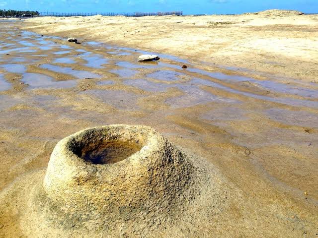
Sand volcanoes, also known as sand boils, are formed when pressurized water and sand are forced upward through overlying layers of soil, creating cone-shaped mounds that resemble miniature volcanoes. This phenomenon typically occurs in areas affected by seismic activity or where there is rapid loadiRead more
Sand volcanoes, also known as sand boils, are formed when pressurized water and sand are forced upward through overlying layers of soil, creating cone-shaped mounds that resemble miniature volcanoes. This phenomenon typically occurs in areas affected by seismic activity or where there is rapid loading on water-saturated soils. Here’s a detailed explanation of the process:
1. Presence of Saturated Soil
Sand volcanoes form in areas with loose, water-saturated sandy soils, such as riverbanks, coastal regions, or areas with shallow water tables.
2. Application of Pressure
Seismic Activity: During an earthquake, seismic waves generate intense shaking, increasing the pressure in pore water between sand grains.
Rapid Loading: Sudden heavy loads, like construction or flooding, can also create high pore water pressure.
3. Liquefaction
The increase in pore water pressure can cause the soil to lose its strength and behave like a liquid—a process known as soil liquefaction.
4. Ejection of Water and Sand
As the pressure builds, water and sand are forced upward through weak points in the overlying soil, creating fissures or vents.
The ejected materials pile up around the vent, forming a small cone-shaped mound, resembling a miniature volcano.
5. Formation of the Cone
The sand and water eventually settle, leaving a cone-shaped structure made of sand. Sometimes, fine sediments are deposited in and around the vent, forming a crater-like depression.
6. Post-Event Features
Sand volcanoes often leave behind circular or elongated patterns on the ground surface, providing evidence of past seismic activity.
Examples of Sand Volcano Formation
Earthquake-Triggered: During major earthquakes, such as the 1964 Alaska earthquake or the 1995 Kobe earthquake, numerous sand volcanoes were observed in liquefied areas.
Human-Induced: Sand boils can also occur during construction projects involving rapid soil loading.
These formations are not dangerous in themselves but often indicate underlying soil instability, which can pose significant risks to infrastructure and buildings in the affected area.
See lessThe Indus Valley Civilization is believed to have been primarily centered in which present-day country?
Please login to vote and see the results.
Weather patterns form due to complex interactions between the Earth's atmosphere, oceans, land surfaces, and solar energy. These patterns are influenced by factors such as temperature, pressure, moisture, and the Earth's rotation. Here's an explanation of the primary processes involved: 1. Solar EneRead more
Weather patterns form due to complex interactions between the Earth’s atmosphere, oceans, land surfaces, and solar energy. These patterns are influenced by factors such as temperature, pressure, moisture, and the Earth’s rotation. Here’s an explanation of the primary processes involved:
Weather patterns emerge from the interplay of these factors on different scales, from localized thunderstorms to global climate systems. Monitoring and understanding these processes help meteorologists predict short-term weather and long-term climate trends.
See lessWhat are the main principles of thermodynamics?
The main principles of thermodynamics are encapsulated in the four laws of thermodynamics, which provide a framework for understanding energy, heat, and work in physical systems. These laws are foundational in physics, chemistry, and engineering. Here's an overview: Zeroth Law of Thermodynamics StatRead more
The main principles of thermodynamics are encapsulated in the four laws of thermodynamics, which provide a framework for understanding energy, heat, and work in physical systems. These laws are foundational in physics, chemistry, and engineering. Here’s an overview:
ΔU=Q−W Where:
These principles collectively govern how energy and matter interact and transform in all physical processes.
See lessWhich ruler has built Sanchi Stupa ?
Please login to vote and see the results.
The water cycle, also known as the hydrological cycle, is a continuous process through which water moves through the Earth's atmosphere, land, and oceans. It consists of the following key stages: Stage Description 1. Evaporation - Water from oceans, rivers, lakes, and other water bodies turns into wRead more
The water cycle, also known as the hydrological cycle, is a continuous process through which water moves through the Earth’s atmosphere, land, and oceans. It consists of the following key stages:
| Stage | Description |
|---|---|
| 1. Evaporation | – Water from oceans, rivers, lakes, and other water bodies turns into water vapor due to heat from the Sun. – Plants contribute through transpiration, releasing water vapor from their leaves. |
| 2. Condensation | – Water vapor rises and cools in the atmosphere, forming tiny droplets that combine to create clouds. – This process releases heat, helping regulate atmospheric temperature. |
| 3. Precipitation | – When water droplets in clouds become heavy, they fall back to Earth as rain, snow, sleet, or hail. – Precipitation replenishes water in rivers, lakes, and soil. |
| 4. Runoff | – Water flows over land surfaces into streams, rivers, and eventually into larger water bodies like oceans. – Runoff also carries sediments and nutrients, shaping landscapes. |
| 5. Infiltration | – Part of the precipitation seeps into the ground, replenishing groundwater aquifers. – This process is crucial for underground water storage and plant root absorption. |
| 6. Groundwater Flow | – Groundwater moves slowly through soil and rock layers, eventually feeding into rivers, lakes, and oceans. |
| 7. Sublimation | – In some areas, ice and snow directly convert into water vapor without becoming liquid, especially in cold, dry conditions. |
| 8. Deposition | – Water vapor can directly turn into ice without passing through the liquid stage, forming frost or snow. |
The water cycle is an interconnected system ensuring the continuous movement of water, essential for all forms of life on Earth.
See lessThe Red Fort is located in which city?
Please login to vote and see the results.
Consider the following statements: Once the Central Government notifies an area as a ‘Community Reserve’ ...Read more
Please login to vote and see the results.
Statement 1: "The Chief Wildlife Warden of the State becomes the governing authority of such forest." This is incorrect. As per Section 36D of the Wildlife (Protection) Amendment Act 2002, a Community Reserve management committee is formed by the State Government, and this committee, not the Chief WRead more
Conclusion:
Thus, the correct answer is Only three.
See lessWhat is photosynthesis, and why is it important?
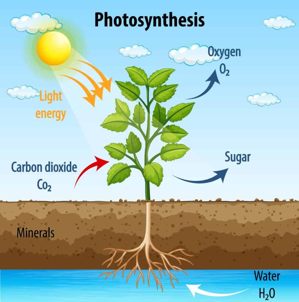
Photosynthesis is a chemical process that plants, algae, and some bacteria use to create food and energy. It's important because it: Provides food and energy Photosynthesis is the primary source of food and energy for all living organisms. Animals that eat plants get their energy from the sugar storRead more
Photosynthesis is a chemical process that plants, algae, and some bacteria use to create food and energy. It’s important because it:
Provides food and energy
Photosynthesis is the primary source of food and energy for all living organisms. Animals that eat plants get their energy from the sugar stored in plants, and animals that eat those animals get the same energy.
Produces oxygen
Photosynthesis releases oxygen into the atmosphere, which all living species need.
Regulates carbon dioxide and oxygen levels
Photosynthesis helps keep the levels of carbon dioxide and oxygen in an ecosystem in check.
Influences agricultural crop productivity
The rate of photosynthesis affects how productive agricultural crops are.
Creates fossil fuels
The energy stored in fossil fuels like petroleum, natural gas, and coal comes from the sun via photosynthesis.
Here’s how photosynthesis works:
1. Light-dependent reactions
Chlorophyll, a pigment in plants, absorbs light energy from the sun. This breaks down water molecules to create energy and oxygen.
2. Calvin cycle
The energy created in the light-dependent reactions fuels the Calvin cycle, a light-independent reaction that converts carbon dioxide into glucose.
Consider the following statements: Statement-I: India, despite having uranium deposits, depends on coal for most of its electricity production. Statement-II: Uranium, enriched to the extent of at least 60%, is required for the production of electricity. Which one of the following ...Read more
Please login to vote and see the results.
Let's analyze each statement: Statement-I: India, despite having uranium deposits, depends on coal for most of its electricity production. This statement is correct. Although India has some uranium deposits, they are not sufficient to meet the country’s nuclear energy needs. As a result, India imporRead more
Let’s analyze each statement:
Statement-I: India, despite having uranium deposits, depends on coal for most of its electricity production. This statement is correct. Although India has some uranium deposits, they are not sufficient to meet the country’s nuclear energy needs. As a result, India imports uranium and heavily relies on coal, which is abundant and cheaper, for most of its electricity production.
Statement-II: Uranium, enriched to the extent of at least 60%, is required for the production of electricity. This statement is incorrect. For nuclear reactors used in electricity production, uranium is typically enriched to about 3-5% U-235. Enrichment levels of 60% and above are considered high and are used for research reactors or weapons-grade material, not for commercial electricity generation.
Therefore, the correct answer is: Statement-I is correct but Statement-II is incorrect.
See lessWhat emerging technologies (e.g., quantum computing, metaverse) will dominate the next decade?
Mindfulness and Meditation exercise Healthy Eating Habits Time Management Sleep Hygiene( quality of sleep)
Mindfulness and Meditation
exercise
Healthy Eating Habits
Time Management
Sleep Hygiene( quality of sleep)
What is Qukut? Qukut is a social question-and-answer platform designed to empower users by combining knowledge sharing with the ability to earn money. It serves as a space where users can: Ask questions: Gain insights and answers to diverse queries. Answer questions: Share expertise and earn rewardsRead more
Qukut is a social question-and-answer platform designed to empower users by combining knowledge sharing with the ability to earn money. It serves as a space where users can:
Qukut bridges the gap between social networking, learning, and earning:
what does the book why bharat matters signify ?
"Why Bharat Matters" by S. Jaishankar is a profound exploration of India's position in the global political arena, seen through the lens of its rich civilizational history. Jaishankar, India’s External Affairs Minister, delves into India’s foreign policy, utilizing historical, cultural, and philosopRead more
“Why Bharat Matters” by S. Jaishankar is a profound exploration of India’s position in the global political arena, seen through the lens of its rich civilizational history. Jaishankar, India’s External Affairs Minister, delves into India’s foreign policy, utilizing historical, cultural, and philosophical insights to illustrate the nation’s evolving role in world affairs.
A key feature of the book is its integration of India’s ancient epics, particularly the Ramayana and Mahabharata, to shed light on contemporary geopolitical challenges. By drawing comparisons between mythological figures like Hanuman and Sri Krishna and modern leadership, Jaishankar provides valuable perspectives on resilience, strategic thinking, and diplomacy
The book emphasizes India’s deep-rooted cultural values and its long history of engagement with the world. Jaishankar illustrates India’s humanitarian contributions, from disaster relief efforts to global health support, positioning India as a compassionate and reliable global partner
Jaishankar’s writing is accessible yet intellectually rich, offering readers a comprehensive view of India’s global aspirations while encouraging them to embrace the country’s civilizational virtues as a guiding force for international diplomacy
“Why Bharat Matters” is highly recommended for anyone interested in understanding India’s foreign policy, its cultural heritage, and its significant role in shaping the global order. It’s an insightful read for policymakers, scholars, and general readers alike. For more information, you can find the full review and more details on the book’s insights on various platforms like ReadByCritics.
What is the significance of “Nelson” in cricket?
In cricket, the term "Nelson" refers to scores that are considered unlucky, typically associated with the numbers 111, 222, 333, and so on. These are multiples of 111, and the superstition stems from the belief that these scores resemble a wicketless set of stumps, possibly symbolizing bad luck. OriRead more
In cricket, the term “Nelson” refers to scores that are considered unlucky, typically associated with the numbers 111, 222, 333, and so on. These are multiples of 111, and the superstition stems from the belief that these scores resemble a wicketless set of stumps, possibly symbolizing bad luck.
Origin of the Term:
1. Lord Nelson Connection: The term is often linked to Admiral Lord Nelson, the British naval hero. It is humorously claimed that Nelson had “one eye, one arm, and one leg” during battle, hence the association with 111. However, this claim is historically inaccurate, as Nelson had both legs. Despite this, the superstition persisted in cricket folklore.
2. Superstition in Cricket: The belief is that “Nelson” scores bring bad luck, and a wicket might fall when a team or player reaches such a score.
Practices and Traditions:
Umpire David Shepherd’s Ritual: The superstition gained more attention thanks to David Shepherd, a famous cricket umpire. Whenever the score reached a Nelson (111, 222, etc.), Shepherd would hop on one leg, supposedly to ward off bad luck. This quirky ritual became iconic in cricket.
Fans’ Reactions: Fans and players sometimes exhibit nervousness or perform small superstitions when a team or player is stuck on a Nelson score.
Modern View:
While the “Nelson” superstition is mostly a light-hearted tradition, it remains an entertaining and quirky aspect of cricket culture, highlighting the sport’s blend of historical anecdotes and superstition.
See lessBody Mass Index (BMI) is a numerical value derived from an individual's weight and height, used as a screening tool to categorize a person's body weight relative to their height. It helps to identify whether an individual has a healthy body weight, is underweight, overweight, or obese. How BMI is CaRead more
Body Mass Index (BMI) is a numerical value derived from an individual’s weight and height, used as a screening tool to categorize a person’s body weight relative to their height. It helps to identify whether an individual has a healthy body weight, is underweight, overweight, or obese.
The formula for BMI is: 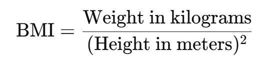
Alternatively, in pounds and inches:
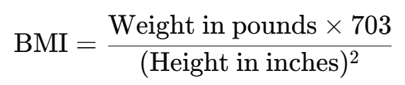
BMI Categories:
Despite its limitations, BMI is widely used as a general indicator of health related to body weight
See lessTaenia solium is the pork tapeworm, a parasitic flatworm (helminth) that infects both humans and pigs. Type of organism: Parasitic cestode (tapeworm) Hosts: Definitive host: Humans (adult worm lives in the small intestine) Intermediate host: Pigs (larval cysts in muscles) — but humans can also becomRead more
Taenia solium is the pork tapeworm, a parasitic flatworm (helminth) that infects both humans and pigs.
Type of organism: Parasitic cestode (tapeworm)
Hosts:
Definitive host: Humans (adult worm lives in the small intestine)
Intermediate host: Pigs (larval cysts in muscles) — but humans can also become accidental intermediate hosts.
Diseases caused:
Transmission:
Eating undercooked or raw pork containing cysticerci (larvae).
Consuming food or water contaminated with tapeworm eggs from human feces.
Significance: Recognized by the WHO as a major cause of preventable epilepsy worldwide, especially in parts of Latin America, Africa, and Asia.

GRAP Stage 3 entails a ban on non-essential construction work. Classes up to grade V are required to shift to hybrid mode under Stage 3. Parents and students have the option to choose online education wherever available. Under Stage 3, the use of BS-III petrol and BS-IV diesel cars (4-wheelers) is rRead more
GRAP Stage 3 entails a ban on non-essential construction work. Classes up to grade V are required to shift to hybrid mode under Stage 3. Parents and students have the option to choose online education wherever available.
Under Stage 3, the use of BS-III petrol and BS-IV diesel cars (4-wheelers) is restricted in Delhi and nearby NCR districts. Persons with disabilities are exempt.
Stage 3 also bans non-essential diesel-operated medium goods vehicles with BS-IV or older standards in Delhi. The Stage 3 of GRAP was lifted on December 27 after a marked improvement in Delhi’s air quality following day-long rainfall in the national capital.
Throughout 2024, Delhi recorded the highest number of ‘severe’ AQI days since 2022, with 17 days exceeding an AQI of 400. Additionally, 70 days were classified as ‘very poor’. Not a single ‘good’ air quality day was recorded in 2024, a first since 2018.
See lessWhat would you do if you had unlimited time and resources?
If I had unlimited time and resources, my focus would be on bringing about social reform through education. My goal would be to ensure that every individual, regardless of their economic, social, or geographical background, has access to quality education. I would start by working towards providingRead more
If I had unlimited time and resources, my focus would be on bringing about social reform through education. My goal would be to ensure that every individual, regardless of their economic, social, or geographical background, has access to quality education.
I would start by working towards providing equal educational opportunities, particularly in rural areas, backward regions, and urban slums, where children often miss out on education. I would establish schools and learning centers that not only provide academic education but also teach life skills, moral values, and career guidance, helping children build a holistic future.
Furthermore, I would initiate a strong movement to reform the education system, making it more inclusive, progressive, and adaptable to the changing world. This would involve incorporating practical knowledge, fostering critical thinking, and encouraging creativity. The ultimate aim would be to empower the youth, provide them with the tools to succeed, and create a more enlightened, equal, and progressive society.
One key tool I would use to achieve this vision is Qukut, a platform where individuals can share knowledge, ask questions, and engage in meaningful discussions. Qukut can serve as a bridge to connect experts, teachers, and learners from diverse backgrounds, facilitating a continuous exchange of ideas and knowledge. It would provide an opportunity for people to not only learn from one another but also contribute to the educational growth of society. Through Qukut, I aim to create a global community of learners and educators who are committed to spreading knowledge and creating positive change.
See lessWhat is the difference between AC and DC electricity?
The difference between AC (Alternating Current) and DC (Direct Current) electricity lies in the direction in which the current flows: 1. Alternating Current (AC): Direction: The current reverses direction periodically. Frequency: It has a frequency (e.g., 50 Hz or 60 Hz, depending on the country), mRead more
The difference between AC (Alternating Current) and DC (Direct Current) electricity lies in the direction in which the current flows:
1. Alternating Current (AC):
Direction: The current reverses direction periodically.
Frequency: It has a frequency (e.g., 50 Hz or 60 Hz, depending on the country), meaning the current changes direction multiple times per second.
Voltage: Can be easily transformed to different voltages using transformers.
Usage: Commonly used in households and industries for power supply because it is more efficient for transmitting electricity over long distances.
2. Direct Current (DC):
Direction: The current flows in one constant direction.
Frequency: It has no frequency because the current doesn’t alternate.
Voltage: Typically used in low-voltage applications but can be converted to higher voltages if needed.
Usage: Found in batteries, solar panels, and electronic devices like laptops and smartphones, as they require a stable and consistent voltage.
Each type of current has specific applications based on its characteristics and efficiency in particular scenarios.
See lessHow can self-healing materials based on bio-inspired polymer networks be engineered for aerospace applications, considering constraints like extreme temperature variations, mechanical fatigue resistance, and the integration of autonomous damage detection and repair systems without compromising structural integrity?
Engineering self-healing materials based on bio-inspired polymer networks for aerospace applications involves a multidisciplinary approach that combines material science, bioengineering principles, and advanced system integration. Given the stringent constraints of extreme temperature variations, meRead more
Engineering self-healing materials based on bio-inspired polymer networks for aerospace applications involves a multidisciplinary approach that combines material science, bioengineering principles, and advanced system integration. Given the stringent constraints of extreme temperature variations, mechanical fatigue resistance, and the need for autonomous damage detection and repair systems, the design of these materials must address several critical factors while maintaining the structural integrity of aerospace components. Here’s a detailed framework for achieving this:
1. Bio-Inspired Polymer Networks
Bio-inspired materials mimic natural processes, such as the healing mechanisms seen in biological systems, to autonomously repair damage and restore functionality. In aerospace applications, bio-inspired polymers must be engineered with specific properties to perform under extreme conditions.
Polymer Matrix Design: The base polymer network should be thermally stable and capable of withstanding the broad temperature variations typical in aerospace environments, ranging from high temperatures during re-entry to low temperatures at high altitudes. For this purpose, high-performance thermosetting polymers, such as epoxies, polyimides, or phenolic resins, can be modified with bio-inspired strategies to improve their resilience to thermal stresses.
Bio-Inspired Healing Mechanism: A typical bio-inspired approach involves incorporating microcapsules or vascular networks within the polymer matrix. These microcapsules contain healing agents (e.g., epoxy resins, self-healing adhesives) that are released when the material undergoes mechanical damage. Alternatively, a vascular network filled with healing agents like liquid polymers or hydrogel solutions can be embedded into the material. Upon crack formation, the healing agent flows to the damaged area, triggers polymerization, and restores the material’s integrity.
2. Extreme Temperature Variations
Aerospace materials are exposed to extreme thermal cycling due to the rapidly changing environmental conditions during flight. Materials must be engineered to ensure that the healing process can still occur under such conditions without compromising the overall material strength.
Thermal Stability of Healing Agents: The healing agents used in self-healing materials should be selected for their high thermal stability and ability to remain liquid or semi-fluid at low temperatures but able to quickly polymerize or bond when exposed to heat. For example, healing agents can be chosen based on their viscosity-temperature relationship to ensure flowability in colder conditions and rapid curing at higher temperatures.
Thermo-responsive Polymers: Integrating thermo-responsive or shape-memory polymers into the material structure can facilitate healing at specific temperatures. These polymers can change their state when heated, allowing them to flow into cracks or damaged areas and facilitate self-healing under the appropriate temperature conditions.
3. Mechanical Fatigue Resistance
Aerospace components experience significant mechanical fatigue, leading to microcracks and eventual failure if not properly addressed. For self-healing materials to be effective, they must not only repair these cracks but also maintain their fatigue resistance over multiple cycles.
Reinforcement with Nanomaterials: Incorporating nanomaterials like carbon nanotubes (CNTs), graphene, or nanofibers into the polymer matrix can enhance the mechanical properties of the self-healing material. These reinforcements improve the fatigue resistance, tensile strength, and flexibility of the polymer network, making it more resistant to damage and fatigue over time.
Adaptive Healing Mechanism: The healing agents must be tailored to restore mechanical properties after crack formation. This could involve using nanoparticle-based healants that fill and reinforce the damaged area at the molecular level, improving the material’s resistance to fatigue.
4. Autonomous Damage Detection and Repair Systems
For self-healing materials to function effectively, they must include an autonomous damage detection and repair mechanism that detects when and where healing is needed and activates the healing process accordingly.
Integrated Sensing Systems: Incorporate embedded sensors (such as piezoelectric sensors or optical fibers) that can continuously monitor the integrity of the material. These sensors can detect damage, such as cracks or deformations, by measuring changes in the material’s electrical, thermal, or optical properties.
Smart Polymers for Detection and Repair: Use smart polymers that change color, transparency, or texture when damage occurs. These polymers can indicate where healing is required, providing visual cues to the system or triggering the release of healing agents. Conductive polymers can also detect mechanical stress and trigger a repair response when damage is sensed.
Energy-Efficient Healing Activation: Autonomous systems can leverage local heating (using integrated micro-heaters or laser sources) to activate the healing process in the damaged area, ensuring that the energy required for healing is efficiently delivered only when needed. This minimizes energy consumption while ensuring optimal healing performance.
5. System Integration and Structural Integrity
To maintain the structural integrity of aerospace materials, the self-healing system must be well-integrated into the material without compromising the strength, weight, or performance of the material.
Distributed Healing Networks: The self-healing system must be designed to distribute healing agents across the material in a way that does not compromise the material’s load-bearing capacity. Vascular or networked systems of microcapsules or channels should be designed to minimize disruption to the mechanical properties of the material while ensuring that healing agents can flow to damaged regions quickly and effectively.
Multiscale Design: The material design should employ a multiscale approach, integrating both macro-structural properties (such as the overall geometry and strength of the component) and micro-structural properties (such as the local behavior of polymers and nanomaterials at the molecular level). This approach ensures that self-healing capabilities are integrated seamlessly into the overall material structure without causing unnecessary weight penalties or compromising other performance metrics.
6. Lifecycle and Long-Term Performance
Aerospace materials must not only perform well in the short term but must also retain their self-healing properties over long durations, often in extreme environments.
Long-Term Durability of Healing Agents: Healing agents should be chosen for their long-term stability and ability to withstand degradation over the operational life of the aerospace component. The material’s self-healing properties must be durable even after multiple healing cycles.
Environmental Compatibility: The self-healing material should be designed to operate in a range of environmental conditions (e.g., radiation, moisture, temperature cycling) without losing its self-healing capacity. Biodegradable or recyclable materials should also be considered for sustainability.
Conclusion
Designing self-healing materials for aerospace applications that can withstand extreme temperature variations, mechanical fatigue, and integrate autonomous damage detection and repair requires a careful balance of material science, bio-inspired design principles, and advanced system integration. By using high-performance bio-inspired polymers, reinforcement with nanomaterials, adaptive healing mechanisms, integrated sensor systems, and energy-efficient activation methods, it is possible to create materials that not only repair themselves but also ensure the long-term integrity and safety of aerospace structures.
See lessWhat is the function of the digestive system?
The digestive system is responsible for breaking down food into nutrients, which the body can absorb and use for energy, growth, and cell repair. It also plays a crucial role in eliminating waste. Here's a breakdown of its main functions: Functions of the Digestive System Ingestion: The process begiRead more
The digestive system is responsible for breaking down food into nutrients, which the body can absorb and use for energy, growth, and cell repair. It also plays a crucial role in eliminating waste. Here’s a breakdown of its main functions:
Each part of the digestive system, from the mouth to the anus, plays a specific role in ensuring that the body gets the nutrients it needs and effectively eliminates waste.
See less
Introduction: 10 most powerful bows In the modern world, we look to particle accelerators and nuclear payloads to define the limits of destructive power. But thousands of years ago, the thinkers of the Indian subcontinent conceptualized a terrifyingly advanced form ...
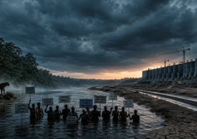
The Ken-Betwa Link Project (KBLP) is no longer just a blueprint on a map; it is a massive, active engineering reality that serves as the vanguard for India’s National Perspective Plan (NPP) for inter-basin water transfer. Aimed at ending the ...

Patriot vs Nationalist: Introduction The words patriot and nationalist are often used as if they mean the same thing. Both express a strong connection to one’s country, both evoke pride, and both can inspire people to act in the name ...
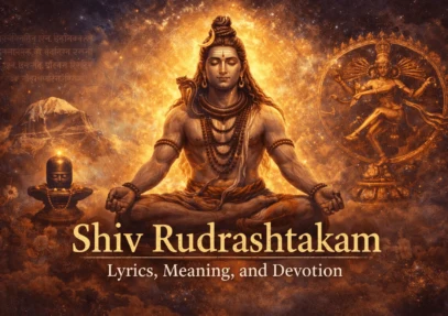
Introduction: The Eternal Hymn of Detachment and Devotion Shiv Rudrashtakam is one of the most profound Sanskrit hymns dedicated to Lord Shiva, the supreme yogi, destroyer of ignorance, and embodiment of pure consciousness. Composed by Adi Shankaracharya, this eight-verse stotra ...
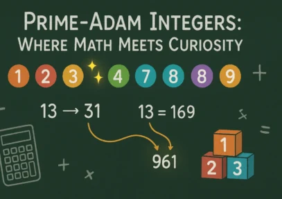
A Prime-Adam Number is defined as a positive number that fulfills two conditions simultaneously: it is a prime number and also an Adam number. For example, take the number 13; its reverse is 31. The square of 13 is 169, and the ...

Introduction The 74th Miss Universe pageant, held on November 21, 2025, at the Impact Challenger Hall in Nonthaburi, Thailand, set a new benchmark in global beauty contests. Not merely a showcase of beauty and fashion, this year’s event stood as ...
Statement 1 is incorrect because, as per Article 71(2) of the Indian Constitution, the actions performed by a person in the capacity of President or Vice-President remain valid even if their election is declared void by the Supreme Court. Article 71(2) explicitly states that such acts shall not be iRead more
Statement 1 is incorrect because, as per Article 71(2) of the Indian Constitution, the actions performed by a person in the capacity of President or Vice-President remain valid even if their election is declared void by the Supreme Court. Article 71(2) explicitly states that such acts shall not be invalidated due to the court’s declaration. It reads: “If the election of a person as President or Vice-President is declared void by the Supreme Court, acts done by him in the exercise and performance of the powers and duties of the office of President or Vice-President, as the case may be, on or before the date of the decision of the Supreme Court shall not be invalidated by reason of that declaration.”
Statement 2 is also incorrect. The Constitution of India does not have any provision allowing for the postponement of the Presidential election due to the dissolution of some Legislative Assemblies. The election must be held within the prescribed time, regardless of such dissolutions.
Statement 3 is incorrect because Article 111 of the Constitution, which outlines the process of granting or withholding assent to bills, does not impose a specific time limit for the President to act on a bill. Article 111 states: “When a Bill has been passed by the Houses of Parliament, it shall be presented to the President, and the President shall declare either that he assents to the Bill, or that he withholds assent therefrom.” There is no mention of a time frame within which the President is required to make this decision. The President may, however, return a non-Money Bill for reconsideration by Parliament, but even here, the Constitution does not set a specific deadline for the President’s assent.
See less