Introduction to Tropical Storm Sara
Tropical Storm Sara emerged in the western Caribbean on November 14, 2024, marking itself as the 18th named storm of the Atlantic hurricane season. Initially classified as Tropical Depression 19, it quickly intensified, showcasing maximum sustained winds of approximately 40 mph (64 km/h) as it approached the coasts of Honduras and Nicaragua. The storm’s formation is significant not only due to its timing—late in the hurricane season, which officially runs from June 1 to November 30—but also because it poses a serious threat of heavy rainfall and flooding across Central America. Meteorologists predict that Sara could unleash between 10 to 30 inches of rain in certain areas, particularly in Honduras, leading to potentially catastrophic flash flooding and mudslides.
The development of tropical storms like Sara is a critical aspect of meteorological study, especially during hurricane season. Understanding the formation and trajectory of such storms is essential for timely warnings and preparedness measures. The National Hurricane Center (NHC) monitors these systems closely, providing forecasts that help communities prepare for severe weather impacts. The late-season formation of Sara underscores the evolving nature of climate conditions; warmer ocean temperatures have contributed to an unusually active hurricane season this year, with predictions of above-average storm activity.
Importance of Tracking Tropical Storms During Hurricane Season
Tracking tropical storms during hurricane season is paramount for several reasons:
- Public Safety: Accurate tracking allows for timely alerts and warnings to be issued, helping residents in affected areas prepare for potential evacuations or safety measures. The NHC plays a crucial role in disseminating information about storm paths and expected impacts, which can save lives and minimize property damage.
- Emergency Preparedness: Communities can better prepare their emergency response plans based on the projected paths and intensities of storms. This includes stocking up on supplies, securing properties, and ensuring that emergency services are ready to respond effectively.
- Understanding Climate Trends: Monitoring these storms contributes to broader climate research. Analyzing patterns in storm formation and intensity helps scientists understand changes in weather systems due to climate change. For instance, the unusually warm waters in the Gulf of Mexico this year have been linked to increased storm activity, prompting discussions about future hurricane seasons.
During hurricane season, Tropical Storm Sara serves as a reminder of the value of close observation. The ability to predict and respond to such weather events is crucial for safeguarding lives and property against the increasingly unpredictable nature of tropical storms in our changing climate.
Formation and Current Status of Tropical Storm Sara
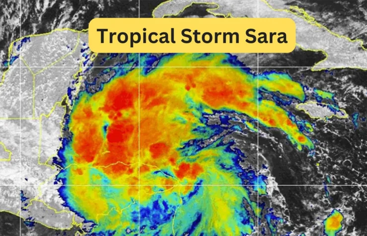
Tropical Storm Sara formed in the western Caribbean Sea on November 14, 2024, evolving from a system initially classified as Tropical Depression 19. This transition occurred approximately 50 miles northeast of the border between Honduras and Nicaragua, where the storm began to exhibit organized convection and sustained winds sufficient to meet tropical storm criteria, reaching 40 mph (64 km/h) at its peak intensity. The formation of Sara is significant as it marks the 18th named storm of the 2024 Atlantic hurricane season, which has seen above-normal activity due to unusually high ocean temperatures and favorable atmospheric conditions that support storm development.
As of November 15, 2024, Tropical Storm Sara is moving westward at a speed of about 10 to 15 mph (16 to 24 km/h) and is currently located approximately 205 miles east-southeast of Isla Guanaja, Honduras. The storm’s trajectory has raised significant concerns for Central America, especially Honduras, where it is expected to bring catastrophic rainfall and the risk of severe flooding and mudslides. Forecasts indicate that areas in northern Honduras could receive between 10 to 30 inches of rain, leading to potentially life-threatening conditions.
The significance of Sara as the 18th named storm in this year’s hurricane season cannot be understated. The Atlantic hurricane season typically runs from June 1 to November 30, with an average of 14 named storms occurring each year. However, the current season has already surpassed this average with a total of 17 named storms prior to Sara’s formation. This unusual activity highlights the ongoing challenges posed by climate change, which has been linked to increased sea surface temperatures and altered weather patterns conducive to storm development.
Tropical Storm Sara’s formation represents not only a significant meteorological event but also a reminder of the importance of preparedness and monitoring during hurricane season. As it continues its path toward Central America and potentially into the Gulf of Mexico, communities are urged to stay informed through updates from meteorological authorities and prepare for possible impacts.
Projected Path and Impact of Tropical Storm Sara
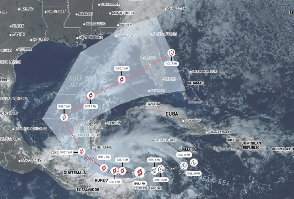
Tropical Storm Sara is currently projected to follow a trajectory that takes it westward across Central America, with significant implications for the region. After making landfall on November 14, 2024, near the Honduras-Nicaragua border, the storm is expected to continue moving west towards Belize and the Yucatan Peninsula of Mexico. This path places several countries at risk, particularly Honduras, Belize, Guatemala, and parts of southern Mexico, as the storm is anticipated to linger near the coast before advancing further into the Gulf of Mexico.
Expected Trajectory Towards Central America, Belize, and the Yucatan Peninsula

As of mid-November 2024, Tropical Storm Sara is tracking west at approximately 10 to 15 mph (16 to 24 km/h). The storm’s movement is characterized by a slow crawl along the northern coast of Honduras, where it is expected to stall for several days. The region’s rainfall totals will be further worsened by this stalemate. Forecast models indicate that after impacting Honduras, Sara will shift northwesterly towards Belize and the Yucatan Peninsula by late Sunday into Monday. Meteorologists warn that this trajectory could lead to severe weather conditions as the storm approaches these areas, with authorities issuing tropical storm warnings in anticipation of hazardous conditions.
Potential for Heavy Rainfall and Associated Risks
One of the most alarming aspects of Tropical Storm Sara is its potential for heavy rainfall, with forecasts predicting between 10 to 30 inches of rain in various regions. Northern Honduras is particularly vulnerable, with isolated areas likely to experience up to 30 inches of rain, leading to life-threatening flash flooding and mudslides. The mountainous terrain in regions like Sierra La Esperanza heightens these risks, as heavy rains can quickly lead to runoff and landslides. Additionally, coastal areas may face storm surge risks, raising water levels significantly above normal tide levels.
The National Hurricane Center has emphasized that this rainfall poses a catastrophic risk, especially in urban areas where drainage systems may be overwhelmed. Communities are urged to prepare for possible evacuations as emergency services stand ready to respond to flooding incidents. The potential for mudslides also raises concerns for infrastructure stability and road safety in affected regions.
Discussion on How Land Interaction May Weaken the Storm
While Tropical Storm Sara has shown some potential for strengthening due to warm sea surface temperatures in the Caribbean Sea, its interaction with land is expected to inhibit significant intensification. As Sara moves over land—particularly through Honduras and Belize—friction from the terrain will likely weaken the storm’s wind speeds. The combination of land interaction and cooler air over land typically leads to a decrease in tropical storm intensity.
Forecasts suggest that as Sara progresses inland, it may downgrade to a tropical depression by early next week. This weakening trend is crucial as it indicates that while heavy rains will still pose significant threats, the overall wind speed and destructive potential of the storm may diminish. However, uncertainties remain regarding how much moisture will persist as it moves into the Gulf of Mexico, where conditions could still allow for some reorganization.
Tropical Storm Sara presents a complex scenario for Central America and surrounding regions. Its projected path indicates a high likelihood of severe flooding and mudslides due to substantial rainfall totals while simultaneously facing potential weakening from land interaction. Communities are advised to remain vigilant and prepared as forecasts continue to evolve in response to this dynamic weather system.
Forecast Models and Uncertainties for Tropical Storm Sara
As Tropical Storm Sara progresses through the Caribbean, meteorologists are utilizing various forecast models to predict its strength and path. These models provide critical insights into the storm’s potential trajectory and intensity, which are essential for informing the public and preparing for possible impacts.
Overview of Different Forecast Scenarios
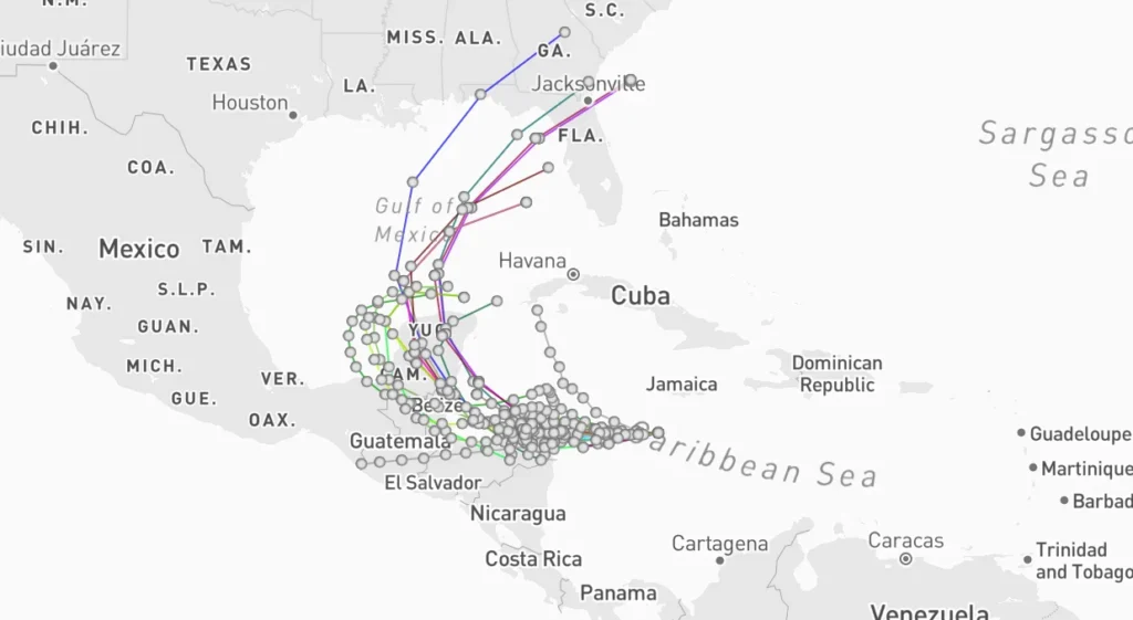
Forecast models, often referred to as “spaghetti models,” illustrate a range of potential paths that Tropical Storm Sara could take. These models incorporate current environmental conditions, historical data, and atmospheric dynamics to generate predictions. Initially, some models suggested that Sara might strengthen into a hurricane as it approached the eastern coast of Honduras. However, as the storm has continued its westward movement, recent updates indicate a shift in trajectory that now places Florida out of immediate threat from direct impacts.
The consensus among the latest models suggests that after traversing Central America, Sara may enter the Gulf of Mexico. Some forecasts predict that the storm could make a right-hand turn towards Florida by late next week, while others indicate that it might dissipate before reaching the U.S. coast. This uncertainty is compounded by varying environmental factors such as wind shear and sea surface temperatures, which can significantly influence a storm’s development and path.
Models Predicting Dissipation in the Gulf of Mexico
Several forecast scenarios highlight the possibility of Tropical Storm Sara weakening as it moves over land and into the Gulf of Mexico. The interaction with land typically diminishes a storm’s intensity due to increased friction and cooler temperatures. Current predictions suggest that Sara could downgrade to a tropical depression by early next week after making landfall in Central America.
As it enters the Gulf, some models indicate that Sara may struggle to regain strength due to cooler waters and unfavorable atmospheric conditions. While there remains a chance for reorganization into a stronger system, many forecasts lean toward dissipation or significant weakening before any potential landfall in Florida. This variability underscores the challenges meteorologists face in accurately predicting tropical storm behavior.
Importance of Staying Updated as Forecasts Evolve

Given the dynamic nature of tropical weather systems, it is crucial for residents in potentially affected areas to stay informed through reliable sources. As Tropical Storm Sara continues to develop, updates from meteorological authorities will provide vital information regarding changes in its path and intensity.
Forecasts can evolve rapidly due to shifts in conditions of the environment, making it essential for communities to monitor developments closely. Local emergency management agencies and national weather services will issue alerts and advisories based on the latest data, which can significantly impact preparedness efforts.
While forecast models provide valuable insights into Tropical Storm Sara’s potential path and strength, uncertainties remain prevalent. The evolving nature of these predictions highlights the importance of ongoing monitoring and preparedness as communities brace for possible impacts from this storm system.
Safety Precautions and Preparedness for Tropical Storm Sara
As Tropical Storm Sara approaches the Western Caribbean and potentially impacts the Gulf Coast and Florida, it is vital for residents in these areas to take proactive measures to ensure their safety. The following recommendations outline essential safety precautions and preparedness strategies that can significantly mitigate risks associated with severe weather events.
Recommendations for Residents in Affected Areas
- Stay Informed: Regularly monitor updates from the National Hurricane Center and local meteorological authorities. Utilize multiple sources, including weather apps, radio broadcasts, and social media, to stay informed about the storm’s path and intensity.
- Develop an Emergency Plan: Families should create a comprehensive emergency plan that includes:
- Evacuation Routes: Identify safe routes to evacuate if necessary and practice them with all family members.
- Communication Plan: Establish a communication strategy to stay in touch with family members during the storm.
- Designated Meeting Places: Choose a local shelter or meeting point in case of separation.
- Create an Emergency Kit: Prepare a disaster supply kit with essential items such as:
- Water (one gallon per person each day for at least three days) and nonperishable food.
- Flashlights, extra batteries, and a first aid kit to address immediate needs during an emergency.
- Important documents (IDs, insurance policies) stored in a waterproof container.
- Medications and personal hygiene items.
- Pet supplies if applicable.
- Secure Your Property: Take steps to protect your home from wind damage:
- Put up storm shutters or use plywood to board up windows.
- Clear gutters and drains to prevent water accumulation.
- Bring in outdoor furniture, decorations, and anything that could become a projectile during high winds.
- Plan for Power Outages: Ensure that you have backup power options available:
- Make sure all electronics are charged before the storm arrives.
- If you live in a place where prolonged power outages are common, think about investing in a generator.
- Heed Evacuation Orders: If local authorities issue evacuation orders, comply promptly. Know your evacuation zones and follow the guidance provided by emergency management officials.
- Avoid Flooded Areas: During the storm, avoid walking or driving through floodwaters. Fast-moving water may knock you down with just six inches, and most cars can be washed away with just one foot.
Importance of Emergency Preparedness Plans in Hurricane Season
The importance of having a well-thought-out emergency preparedness plan cannot be overstated, especially during hurricane season. Preparedness not only enhances individual safety but also strengthens community resilience against natural disasters. Key reasons for prioritizing emergency plans include:
- Minimizing Panic: Having a clear plan reduces confusion and panic during emergencies, allowing families to respond swiftly and effectively when a storm approaches.
- Ensuring Resource Availability: By preparing in advance, residents can secure essential supplies before they become scarce due to high demand as storms approach.
- Facilitating Coordination with Authorities: Well-prepared communities can work more effectively with local emergency services, ensuring that resources are allocated efficiently during disaster response efforts.
- Protecting Lives and Property: Preparedness measures significantly reduce the risk of injury or loss of life during severe weather events by ensuring that individuals know how to respond appropriately.
Conclusion
Tropical Storm Sara poses significant risks as it approaches Central America and potentially impacts the Gulf Coast and Florida. With forecasts predicting heavy rainfall leading to flash flooding and mudslides, it is crucial for residents in affected areas to take immediate action to prepare for potential impacts.
Staying informed through reliable weather updates is essential as conditions evolve rapidly. Residents are encouraged to follow local advisories closely and implement safety precautions outlined above. By prioritizing preparedness efforts now, communities can enhance their resilience against the challenges posed by Tropical Storm Sara and future storms throughout hurricane season.


