What are Llanos??
What are Llanos??
Read lessSign up to our innovative Q&A platform to pose your queries, share your wisdom, and engage with a community of inquisitive minds.
Log in to our dynamic platform to ask insightful questions, provide valuable answers, and connect with a vibrant community of curious minds.
Forgot your password? No worries, we're here to help! Simply enter your email address, and we'll send you a link. Click the link, and you'll receive another email with a temporary password. Use that password to log in and set up your new one!
Please briefly explain why you feel this question should be reported.
Please briefly explain why you feel this answer should be reported.
Please briefly explain why you feel this user should be reported.
Which is the smallest thing in the world?
Which is the smallest thing in the world?
Read lessThe smallest thing in the world is the quark. After the particle accelerator was invented, they broke the atom into as many small pieces as they could. These little pieces are called quarks.
The smallest thing in the world is the quark.
After the particle accelerator was invented, they broke the atom into as many small pieces as they could. These little pieces are called quarks.
La Niña is a natural climate pattern that occurs when the ocean surface temperatures in the central and eastern equatorial Pacific cool below normal
La Niña is a natural climate pattern that occurs when the ocean surface temperatures in the central and eastern equatorial Pacific cool below normal
See lessThe largest lake in the world by surface area is the Caspian Sea. Despite being called a "sea," it is technically a lake because it is not connected to the world's oceans. The Caspian Sea spans an area of approximately 371,000 square kilometers (143,000 square miles) and is bordered by five countrieRead more
The largest lake in the world by surface area is the Caspian Sea. Despite being called a “sea,” it is technically a lake because it is not connected to the world’s oceans. The Caspian Sea spans an area of approximately 371,000 square kilometers (143,000 square miles) and is bordered by five countries: Russia, Kazakhstan, Turkmenistan, Iran, and Azerbaijan.
See lessSmallest lake in the world
Smallest lake in the world
Read lessThe Smallest Lake in the World is often considered to be Benxi Lake in Liaoning Province, China. This lake has an area of just 15 square meters (161 square feet), making it extremely small. Despite its size, it is recognized for its clear waters and picturesque surroundings.
The Smallest Lake in the World is often considered to be Benxi Lake in Liaoning Province, China. This lake has an area of just 15 square meters (161 square feet), making it extremely small. Despite its size, it is recognized for its clear waters and picturesque surroundings.
See lesswhich is the smallest city in the world
which is the smallest city in the world
Read lessThe Vatican City, a city-state surrounded by Rome, Italy, is the headquarters of the Roman Catholic Church. It's home to the Pope and a trove of iconic art and architecture. Its Vatican Museums house ancient Roman sculptures such as the famed “Laocoön and His Sons” as well as Renaissance frescoes inRead more
The Vatican City, a city-state surrounded by Rome, Italy, is the headquarters of the Roman Catholic Church. It’s home to the Pope and a trove of iconic art and architecture. Its Vatican Museums house ancient Roman sculptures such as the famed “Laocoön and His Sons” as well as Renaissance frescoes in the Raphael Rooms and the Sistine Chapel, famous for Michelangelo’s ceiling.
total area: 121 hectares
language: Italian, Latin
Population: 764 (Jun 2023)
Sistine Chapel
San Mar
See lessHow sand volcanos are formed?
How sand volcanos are formed?
Read less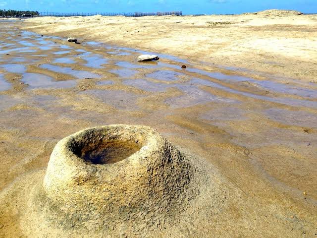
Sand volcanoes, also known as sand boils, are formed when pressurized water and sand are forced upward through overlying layers of soil, creating cone-shaped mounds that resemble miniature volcanoes. This phenomenon typically occurs in areas affected by seismic activity or where there is rapid loadiRead more
Sand volcanoes, also known as sand boils, are formed when pressurized water and sand are forced upward through overlying layers of soil, creating cone-shaped mounds that resemble miniature volcanoes. This phenomenon typically occurs in areas affected by seismic activity or where there is rapid loading on water-saturated soils. Here’s a detailed explanation of the process:
1. Presence of Saturated Soil
Sand volcanoes form in areas with loose, water-saturated sandy soils, such as riverbanks, coastal regions, or areas with shallow water tables.
2. Application of Pressure
Seismic Activity: During an earthquake, seismic waves generate intense shaking, increasing the pressure in pore water between sand grains.
Rapid Loading: Sudden heavy loads, like construction or flooding, can also create high pore water pressure.
3. Liquefaction
The increase in pore water pressure can cause the soil to lose its strength and behave like a liquid—a process known as soil liquefaction.
4. Ejection of Water and Sand
As the pressure builds, water and sand are forced upward through weak points in the overlying soil, creating fissures or vents.
The ejected materials pile up around the vent, forming a small cone-shaped mound, resembling a miniature volcano.
5. Formation of the Cone
The sand and water eventually settle, leaving a cone-shaped structure made of sand. Sometimes, fine sediments are deposited in and around the vent, forming a crater-like depression.
6. Post-Event Features
Sand volcanoes often leave behind circular or elongated patterns on the ground surface, providing evidence of past seismic activity.
Examples of Sand Volcano Formation
Earthquake-Triggered: During major earthquakes, such as the 1964 Alaska earthquake or the 1995 Kobe earthquake, numerous sand volcanoes were observed in liquefied areas.
Human-Induced: Sand boils can also occur during construction projects involving rapid soil loading.
These formations are not dangerous in themselves but often indicate underlying soil instability, which can pose significant risks to infrastructure and buildings in the affected area.
See lessWith reference to India’s projects on connectivity, consider the following statements: [2023] 1. East-West Corridor under Golden Quadrilateral Project connects Dibrugarh and Surat. 2. Trilateral Highway connects Moreh in Manipur and Chiang Mai in Thailand ...Read more
With reference to India’s projects on connectivity, consider the following statements: [2023]
1. East-West Corridor under Golden Quadrilateral Project connects Dibrugarh and Surat.
2. Trilateral Highway connects Moreh in Manipur and Chiang Mai in Thailand via Myanmar.
3. Bangladesh-China-India-Myanmar Economic Corridor connects Varanasi in Uttar Pradesh with Kunming in China.
How many of the above statements are correct?
Read lessLet's analyze each statement one by one: East-West Corridor under Golden Quadrilateral Project connects Dibrugarh and Surat: The East-West Corridor under the Golden Quadrilateral project connects Silchar in Assam to Porbandar in Gujarat, not Dibrugarh to Surat. So, this statement is incorrect. TrilaRead more
Consider the following statements : ...Read more
Consider the following statements : [2023]
1. Amarkantak Hills are at the confluence of Vindhya Sahyadri Ranges.
2. Biligirirangan Hills constitute the easternmost part of Satpura Ranges.
3. Seshachalam Hills constitute the southernmost part of Western Ghats.
Read less
Let's evaluate the above statements: Amarkantak Hill: Recognized as a significant natural heritage site. Serves as the junction of the Vindhya and Satpura Ranges. Therefore, statement 1 is INCORRECT. Biligirirangan Hills: Located in the southeastern region of Karnataka. The Satpura Range, in contrasRead more
Let’s evaluate the above statements:
Therefore, the correct answer is None.
See lessWhich one of the following is a part of the Congo Basin?
Which one of the following is a part of the Congo Basin?
Read lessThe Congo Basin is a large, tropical rainforest region in central Africa that spans across several countries. The main countries that make up the Congo Basin are: Democratic Republic of the Congo (DRC) - It holds the largest portion of the Congo Basin and is home to a significant part of the rainforRead more
The Congo Basin is a large, tropical rainforest region in central Africa that spans across several countries. The main countries that make up the Congo Basin are:
These countries collectively make up the Congo Basin region, which is the second-largest tropical rainforest in the world, after the Amazon. It is known for its rich biodiversity, complex ecosystems, and significant role in regulating the Earth’s climate. So, Cameroon is the correct answer.
See less
The Llanos (pronounced YAH-nos) are vast tropical grasslands located in northern South America, primarily in Venezuela and Colombia, between the Andes Mountains to the west and the Guiana Highlands to the east. These plains form part of the Orinoco River basin and are characterized by their flat terRead more
The Llanos (pronounced YAH-nos) are vast tropical grasslands located in northern South America, primarily in Venezuela and Colombia, between the Andes Mountains to the west and the Guiana Highlands to the east. These plains form part of the Orinoco River basin and are characterized by their flat terrain and unique ecological features.
Key Characteristics of the Llanos:
Ecological Importance:
The Llanos play a crucial role in maintaining the ecological balance of the Orinoco River basin. Seasonal flooding supports the life cycle of many aquatic and terrestrial species, making it a key habitat for wildlife.
The Llanos are tropical grasslands rich in biodiversity and cultural history, serving as a vital ecological region and a significant economic area for Venezuela and Colombia.
See less